Tag Archives: Daunder

Dales Daunder

As some readers will be aware, TGO Challenge legend, Alan Sloman, arranges a pre-TGOC walk every year as a warm up to the Challenge itself. Covid interrupted these for a couple of years, but things have now got back to normal, so the Daunder as it is known was revived. There’s not much of a story to tell, so I’ll just post some pictures. This year we went to the Yorkshire Dales starting at Dent then walking to Ingleton via Whernside. On the second day we walked back to Dent via Ingleborough.

Day 1: Dent to Ingleton via Whernside (19.7km, 669m ascent)

Second breakfast at Dent and a late start

Picturesque Dent

Walking up from Dent

View north on the ascent of Whernside

Whernside Tarns

Ingleborough from Whernside

Sink hole on Whernside

Lambs near Ingleton

Day 2: Ingleton to Dent via Ingleborough (25.8km, 1,041 ascent)

Ingleton

Path up to Ingleborough

Whernside from the top of Ingleborough

Looking back to Ingleborough

Pot hole on western side of Ingleborough

Winterscales Beck

Ribblehead Viaduct

More lambs

Little Dale

Waterfall near Greensett Craggs

A last look at Ingleborough

All in all a fine trip. The second day was quite taxing, but enjoyable. We were lucky with with the weather althought there was a strong cold wind, which is why we skipped a wild camp. It’s a long time since I’ve walked in the Yorkshire Dales. I think I’ll go back and do a bit more exploring.

Lakes Daunder 2018 part 2

Although it was a clear night, the temperature, according my thermometer didn’t get below 9c in the tent. An early start was demanded by Obergruppenführer Sloman, so just to be sure that I would be ready by eight o’clock, I was up by 5.45. There were no clouds in the sky and it looked like it was going to be another glorious day.

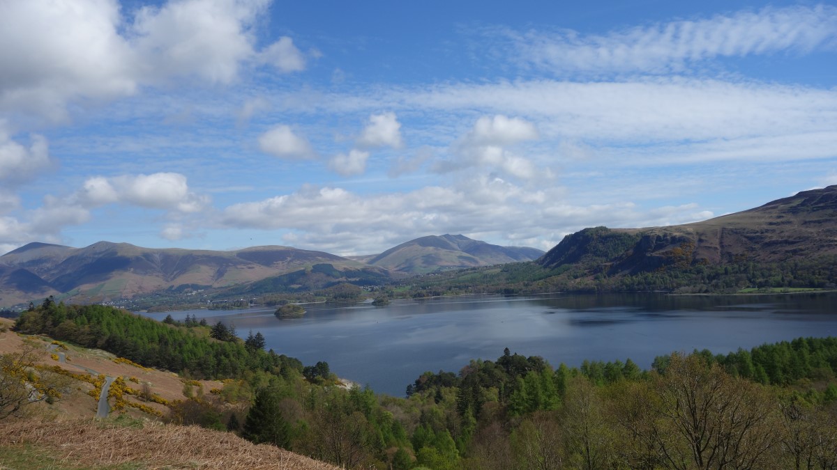
Amazingly, we were all ready almost on time. We climbed Water Crag, a mighty 305m high, although it felt rather more. Yet again we were greeted by glorious views all around.  After a short wait to allow everyone to catch up, it was on to Rough Crag and a group photo opportunity.

(photo courtesy of Alan Sloman)

From here it was downhill all the way for our proposed lunch stop at the Woolpack Inn. We ambled down some country lanes and then diverted to have a look at Stanley Force. What an amazing hidden gem! From the top there’s a spectacular sheer cliff from which to view the waterfall. Then there’s a wonderful path down into a ravine, very reminiscent of a Chinese landscape with rhododendrons and wooden bridges. I’m afraid my photos don’t do justice (partly because the camera was on the wrong setting, whoops!).

Alan was the only member of our party who had decided not to visit the waterfall and we were supposed to meet him at the car park. However, the path had changed and we ended up on the north bank of the Esk. In true Daunder spirit, we decided to carry on without him.

It was a lovely walk along the Esk, some of which I’d done before. We arrived at the Woolpack for lunch just before it got busy. Who should be standing on the doorstep but Alan holding a pint of beer. Over lunch, four of us decided to revive another Daunder tradition: the schism. I suggested that the original route looked a bit dull and the camp spot at Sampson’s Stones might be a bit iffy. The alternative was to walk up the Esk via Throstle Garth and Scar Lathing to a lovely spot to camp in the bend of the Esk opposite Sampson’s Stones. This was enthusiastically embraced by some, so I explained to our leader, Phil, that we were ditching his lovingly planned route. Phil, Alan and Any decided they would stick to the original plan.

It’s impossible to capture in words what a wonderful walk this is, so I’ll just give you a load of pictures. If you’ve never done it, you really must. It’s one of the best walks in the Lakes.

By the time we reached Throstle Garth, there were some high clouds forming, suggesting the weather was on the change. We eschewed a lovely place to camp below Scar Lathing, and pushed on to the spot where I had camped before.

It is a spectacular place to camp. For some reason, I didn’t take many photos. About half an hour after we arrived, our schism started to be healed. First Andy appeared with tales of how rough and pathless his route had been. Then Phil and Alan were spotted picking their way down the slope. Soon our happy(!) band were reunited. All the time the cloud was thickening. Just after I turned in for the night, the thunder and lightning started. Fortunately, it skirted our camp spot but not before there was a very heavy rain/hail shower. There were a few rumbles of thunder during the rest of the night, but nothing serious.

The next day, amazingly, we were all packed in good time. The weather looked threatening, but stayed dry as we walked up the Esk towards Esk Hause. There were some remarkable ripples in the clouds.

Ascending the slope to the gully, Andy decided to veer off left to climb the evocatively named Knotts of Tongue. While Andy took a direct route that involved some scrambling, I branched left to avoid the rocks, then spotted David behind me and decided to wait for him. As we ascended the weather deteriorated and the rain and mist came in. We knew Judith was behind us so, like the gentlemen we are, we waited for her.

At the top there was a strong wind and driving rain, but when we rounded Great End it abated somewhat. I managed to take a couple of pictures at Sprinkling Tarn, but from there on my camera stayed in its plastic bag. It was windy and wet as we picked our way down to Sty Head and then into Wasdale. By this time Judith was some way behind, but she’s an experience backpacker so we weren’t worried. Carefully we wended our way down to the Wasdale Head Inn, where Andy was waiting for us. Judith followed a little later.

After about half an hour the rest of the pack arrived. After some food and liquid refreshment, it was time for me to go back to my camper van and for the rest to drive home. Judith saved me a little walk by kindly giving me a lift back to the campsite. A great time was had by all (I think). Thanks to Phil for organising a great weekend.

Lakes Daunder 2018 part 1

This was my third pre-TGO Challenge Daunder. I’m not actually on the TGO Challenge this year because my wife has been too ill to allow me to be away for a fortnight. However, I will be doing a demi-Challenge for seven days from Ft William to Aviemore, coinciding with the actual Challenge, meeting with at least three Challengers (Alan, Phil and Andy) for part of the way.

This little trip was to test out the muscles and gear for the main event. Compared with last year’s Daunder, which had a cast of thousands, this year it was restricted to only seven. Goodness knows why they invited me, but I’m glad they did as we had a great time and some fabulous weather.

The route (41.4km, 1,824m ascent, 2.5 days) click to enlarge

Unlike the others who stayed at the campsite opposite the Wasdale Head Inn, I took my camper van and stayed at the National Trust campsite at the northern end of Wastwater. I love using my camper van, so any excuse! I’ve now got everything off to a fine art and it’s a brilliant way to have a base camp.

The day dawned dank, grey and claggy but by the time the rest of the motley crew arrived, the cloud was burning off, promising a fine day.

I’ve never walked up Illgill Head. I’m I’ve glad I rectified that; the views were magnificent.

Andy and I were much faster than the others, so we powered on to Whin Rigg where we decided to have an early lunch and see if the others would catch us up.

Just as we were about to make a move, David arrived. Apparently the others were way behind, so we decided to push on.  Rather than take our orignal route we decided to take in Irton Pike. Although this entailed a slightly boggy approach to the woods, the views were worth the effort.

The photos don’t really do justice. One of the joys of the minor peaks in the Lakes is that they give views which are sometimes better than the higher fells. Out to sea, there was fog bank, while to the south there was the contrast the green of Miterdale and the drab brown of Ulpha Fell in the distance.

After a steep descent from Irton Pike there was a delightful stretch in some woodland, before a short road walk to Eskdale Green and a quick visit to the local store for a can of fizzy drink and a banana.

Next stop was the George IV Inn, where we decided we had better stop to wait for the others to catch up. So far, the weather had been lovely with sunshine and every so often a cooling breeze. Just as we were wondering if something had gone wrong, the others arrived. However, we had already had a decent rest, so we decided to leave them to rehydrate and we walked on with the intention of nicking the best camping spots.

After a bit of a navigation faff due to the start of the path not matching the 1;50,000 map, we located the way up Brantrake. It was a bit stony at first and then developed into a beautifully graded zig-zag up the valley side.

When I scouted or intended camp spot below Water Crag on Google satellite, I was a bit dubious about the ground conditions. In the end, they weren’t as bad as I thought. I pinched some flat ground in an abandoned sheep fold while the others spread out on some tussocky grass. Mates!

(to be continued)


TGOC Daunder 2017

Last weekend I took part in the famous TGOC Daunder, preparing for the real thing in just over two weeks time. David has written an account on his blog Fellbound. Instead of repeating his account (however fanciful), I’ll just contribute some photos.

Alan finds some “interesting” photos on the internet.

Steep climb from Little Dale

Lunch on the flank of Robinson

Little Dale and Newlands

“View” from Hindscarth

Towards Dale Head

Newlands from Dale Head

Dale Head Tarn

Borrowdale from Rigghead Quarries

Borrowdale

Camp above Borrowdale

Borrowdale

View from Thornythwaite Fell

View from Thornythwaite Fell

Great Gable

Allen Crags from Glaramara

Tarn between Glaramara and Allen Crags looking towards Langdale

Great Gable

Angle Tarn and Bowfell

Langstrath

Packing up at Stonethwaite camp site

Borrowdale

River Derwent

Borrowdale

Derwent Water and Blencathra

Daunder 2015 part three

DSC00139Although it rained a bit overnight, the next day dawned sunny and bright. By around 8:30 we were all packed and ready for the off.

DSC00140We picked up the Swan’s Way and headed along a broad track past fields …

DSC00142..and cheap council houses.

DSC00143At Swyncombe Downs, we paused for a rest, making use of some cross country jumps for horses as seats.

DSC00144So far, it had been a very pleasant morning’s walk. However, soon, we emerged onto the minor road that led back to the camp site at Crowmarsh Gifford. Unfortunately, it was very busy with traffic including heavy lorries.

DSC00145It was an unavoidable trudge until we picked up a footpath just outside Crowmarsh.

DSC00146Not long after, we were back at the camp site. Phil decided that he should get home, but the rest of us went to the pub for lunch. I had some very fine sausages. All too soon, it was time to say our farewells. All in all, it was a very pleasant two and half days walking, in good company. Thanks to Alan for organising it. Below is a map of the route we took.

PWD 2015 OVERVIEW MAP

Daunder 2015 part two

Henley has one big draw back as a place to camp: it’s under the Heathrow flight path. At around six o’clock in the morning, the planes start coming in. While not deafening, they are certainly noticeable. After an hour or so of trying to ignore the aircraft noise, I gave up and got out of my sleeping bag.

DSC00077Swiss Farm camp site has a restaurant, so it would have been rude not to have breakfast there! I was sorely tempted to have a second plate of scrambled eggs and smoked salmon. We really know how to rough it. Suitably fortified, we had to resume this horrible walking nonsense.

DSC00079A group of us left Phil back at the camp site on his phone to sort out some problems with his impending house move. After a short pull up the hill, through a stretch of woods, we emerged into some open parkland.

DSC00081At the end of the grassy track there was a huge cedar tree.

DSC00085Mick decided it was so lovely, he gave it a hug.

DSC00086Further on, we saw a rather lovely house.

DSC00090And a spooky tree.

DSC00091We also saw some fine-looking horses.

DSC00092Soon, the views began to look like the Shire in Lord of the Rings.

DSC00094Amazingly, Alan and Phil were dissuaded from going into a pub (it was only 10:30).

DSC00097This road sign caused much hilarity.

DSC00099After a rest break at a derelict church, it was onward and upward for a serious climb, accompanied by yet more moaning by Phil.

DSC00101Soon we were walking through a field of yellow rape.

DSC00104Over some rolling downland.

DSC00110Past a pretty church.

DSC00113To a pub in the amusingly named village of Pishill.

DSC00118Food and drink was consumed. After an hour or so, it was time to heft our packs again to resume our journey through some delightful woods with a floor of bluebells.

DSC00122We wended our way through more fields.

DSC00123And woods.

DSC00124To the next pub. Some of us had a cream tea, others didn’t.

DSC00126After sheltering from a spot of rain, we walked to Watlington Hill for a fine view over Watlington and beyond.

DSC00132At the bottom of the hill was our camp site for the night.

DSC00137We had a fine meal in The Chequers in Watlington (our third pub of the day). To round off a perfect day, the rain held off until we were safely tucked up in our tents.

Daunder 2015 part one

Well that was fun! The 2015 Pre-Walk Daunder was successfully completed with no mishaps, revolutions or tantrums. The weather was fine and a jolly time was had by all. Thanks to Alan Sloman for his impeccable organisation.

DSC00040The intrepid Daunderers gathered in dribs and drabs at the appointed camp site in Crowmarsh Gifford. The camp site authorities had obviously been warned that we are a bunch of hooligans because we had a discrete area of the camp site all to ourselves, well away from the more genteel caravanners.

DSC00042Despite a night of debauchery at one of Wallingford’s less salubrious hostelries, the merry band was up bright and early to face the daunting route that Alan had planned for the day. Phil was a bit photo shy and pretended to adjust his hip belt every time someone tried to take a group photo.

DSC00043After a bit of coaxing, we were off through some fields with the promise of lunch at a pub somewhere.

DSC00045Soon, we turned east to follow the Ridgeway along Grim’s Ditch.

DSC00047Along the way there was some lovely woodland with a carpet of bluebells.

DSC00049Before long, Gerry decided that we were going too fast and that we needed a break to reduce our average speed to a more sensible level. JJ decided to entertain us with his Larry Grayson impersonation (well, maybe not).

DSC00052It was all going terribly well, until we encountered some uphill bits. This precipitated a bout of extended moaning from Phil about Alan’s route planning abilities.

DSC00055As we climbed higher, splendid views opened up, including one of Didcot power station, which will soon be required to export electricity to Scotland to keep their lights on when they get rid of their last coal-fired power station. DSC00059All around we  were surrounded by picture postcard loveliness.

DSC00061Before we could reach our lunch time oasis, there was a killer hill to climb.

DSC00063Fortunately no one was injured or lost on the arduous ascent of Witheridge Hill. Miraculously, just over the brow of the hill, The Rising Sun pub came into view.

DSC00065The pub appeared just in time to quell a mutiny amongst the troops. Food and drink calmed tempers and soothed discontent.

DSC00066Suitably refreshed, it was onward and upward, with Captain Sloman leading from the rear.

DSC00068Our path led us through some beautiful woodland. Navigator Sloman decided that the arrows painted on the trees were misleading, so we followed a more novel and circuitous route.

DSC00072There was considerable confusion when a breakaway group decided to take a different route. However, order was restored with another tea break when the rebels re-joined the main party.

DSC00073Alan’s tactic of leading from the rear backfired on the outskirts of Henley. Instead of descending along a ridge, the leading group continued along a path which opened onto the roughest part of Henley. We barely survived.

DSC00075Fortunately, it wasn’t far to the camp site. For some reason, Mick decided that he wanted to follow JJ’s lead and do a Larry Grayson impersonation. Most of the group decided to go on the razzle in Henley, but I was suffering from a heat induced migraine and had an early night.